Knox Township
Jefferson County, Ohio
View Larger Map
GPS reading for GRIMM CEMETERY
Knox Twp.
N40 28.237, W080 41.543
Elevation - 1212
The following information was taken from the book titled,
Knoxville Area History pp. 33 – 34
At the top of the hill on the Jeffery Hill Road, Knox Township road 240, the Jeffery farm still bear some semblance of the fine orchards and poultry buildings for which these farms were so well known in former times. The fields of the neighboring farms adjoining the road, which once were tilled and tended into a high state of production of such families as the Masseys, the Shelly’s and of course, the Grimm's for whom the ridge was named.
The Grimm family first settled in the area known as Grimm’s Ridge in Knox Township by two brothers who came from Maryland in the early 1800’s and began farming the surrounding land. The first recorded deed for the land was to Sarah Grimm in 1878. She retained ownership of the Grimm Cemetery but the 160 acres later was deeded to John Grimm, father of Ford Grimm. Ford Grimm built the barn now standing around 1910, but the original house was destroyed several years ago. Wilbur Grimm and his sister, Mrs. Mary Jane (Grimm) Boring, own the original 160 acres. Wilbur still has cattle there and puts up a little hay.
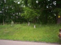
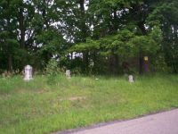
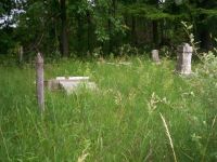
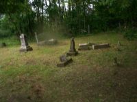
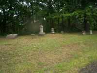
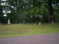
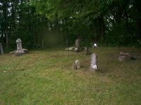
About midway along the road lies the Grimm family burial ground, triangular in shape, and flanked on the right by a lane that leads to the old Stevenson farm and thence past the sugar camp once operated by the Mills family to its terminal at the new Knoxville School. This plot, about a half city lot in extent contains the last remains of many members of the Grimm family dating back to the pioneer days when such burial grounds were common. The number of interments testifies to the important part the Grimm family played in the political and economic life of this Knox Township community.
Many of the cemetery’s dozen worn gravestones are chipped and sunken and most of the inscriptions are worn beyond legibility. Some of the markers, in this hallowed ground, have fallen from their foundations and remain in that position. Several of the stones have been knocked over by vandals. One of the markers, of ancient vintage, appears to be made of a terra cotta with the inscription carved in it from a sharp instrument long before time and the elements have made it indistinguishable.
The earliest dates inscribed are 1811 and 1823. One of the largest monuments is that of Emmanuel Grimm with a date of demise as 1877. The family is so scattered now and each generation has a little less interest in the farm. The township was given the responsibility for its care. It is neglected and in a state of sad repair.
Grimm Cemetery, Knox Twp., Jefferson County, Ohio
Photos taken by chapter members Janet Gray and William Kakascik in July of 2009
They are cutting and caring for the cemetery. Our chapter is planning a restoration/preservation day in the cemetery in the fall 2009 and possibly spring 2010 if needed.
The following was an email sent to Flora from Janet Gray.
Flora,
I am writing to let you know that William(Bill) Kakascik and I (Janet Gray) were
concerned about the condition of Grimm cemetery on township road 242 east.
We drive past the cemetery at least once every week. A lot of the head stone are over turned and the grass was knee high.
Since Billand I are both members of Jefferson County Chapter OGS and live one road over on township road 241 we decided to do something about it. With a camera to take before and after pictures, a weed whacker, clippers and a push mower we went to work to a difference. In almost two hours we were finished just in time because the rain started to pour.
There are most likely some veterans buried in that cemetery and it now is looks
like someone cares.
Janet